 SNAP GeoNetwork
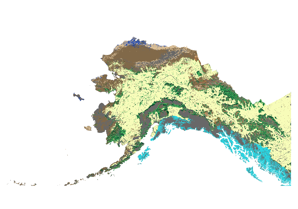
Annual ALFRESCO Model Outputs with Historical Fire Scars
These GeoTIFFs include annual spatial representations of the following variables produced through summarization of ALFRESCO model outputs across 200 replicates:
Flammability: likelihood of a pixel to burn across 200 replicates
Modal vegetation type: statistical mode of vegetation type across 200 replicates
Percent vegetation type: percent of each possible vegetation type across 200 replicates
These outputs were derived from AR5/CMIP5 climate inputs, historical fire inputs from the Alaska Interagency Coordination Center (AICC), and several fire management options (FMO) inputs.
Simple
- Date (Publication)
- 2023-01-31
- Credit
- Alec Bennet
- Credit
- Michael Lindgren
- Credit
- Craig Stephenson
- Status
- Completed
- Maintenance and update frequency
- As needed
- Theme
-
- vegetation
- flammability
- historical
- projected
- modeled
- Use constraints
- License
- Other constraints
- https://creativecommons.org/licenses/by/4.0/
- Spatial representation type
- Grid
- Distance
- 1 km
- Metadata language
- eng
- Character set
- UTF8
- Topic category
-
- Climatology, meteorology, atmosphere
- Begin date
- 1901-01-01
- End date
- 2100-12-31
))
- Supplemental Information
-
Flammability
Flammability is defined as the likelihood of a pixel to burn across all 200 model replicates for each year. This is a value from 0.0 to 1.0, calculated by dividing the number of replicates with a fire at a given pixel by the number of total replicates (200). 1.0 means that all 200 replicates simulated a fire at that pixel. Years that were provided with historical fire polygons (1950-2021) always produce a fire scar for that polygon in the subsequent year, so the flammability for years 1951-2022 are either 0.0 (no fire) or 1.0 (a fire scar across all 200 replicates).
Modal vegetation
Each modal vegetation GeoTIFF pixel has nine possible values:
0: No Vegetation (Not Modeled)
1: Black Spruce
2: White Spruce
3: Deciduous
4: Shrub Tundra
5: Graminoid Tundra
6: Wetland Tundra
7: Barren/Lichen/Moss
8: Temperate Rainforest
These pixel values represent the modal (statistical mode) vegetation type across all 200 replicates for a given pixel. The 5 model average modal vegetation GeoTIFFs were calculated by combining all 200 replicates across all five models and taking the statistical mode across all 1,000 GeoTIFFs (200 replicates * 5 models).
Percent vegetation
Each percent vegetation GeoTIFF has nine bands, representing the following vegetation types:
Band 1: No Vegetation (Not Modeled)
Band 2: Black Spruce
Band 3: White Spruce
Band 4: Deciduous
Band 5: Shrub Tundra
Band 6: Graminoid Tundra
Band 7: Wetland Tundra
Band 8: Barren/Lichen/Moss
Band 9: Temperate Rainforest
The pixel values for each band represent the percentage of the 200 replicates that produced the corresponding vegetation type. For example, if 143 of the 200 replicates produced the “Deciduous” vegetation type for a given pixel, Band 4 will have a value of 71.5 for that pixel.
Included models:
GFDL-CM3
GISS-E2-R
IPSL-CM5A-LR
MRI-CGCM3
NCAR-CCSM4
5 model average
Included emission scenarios:
RCP 4.5
RCP 6.0
RCP 8.5
Included fire management options:
NoFMO: No fire suppression.
FMO: Fire suppression based on the 2022 fire management options geodatabase from AICC, added to the ALFRESCO runs starting in 1950.
AltFMO: The same fire suppression as FMO above, but with additional areas of fire suppression around Fort Wainwright, Fort Greely, and Eielson Air Force Base, added to the ALFRESCO runs starting in 2022.
For background on ALFRESCO, please refer to:
Daniel H. Mann, T. Scott Rupp, Mark A. Olson, and Paul A. Duffy. Is Alaska's Boreal Forest Now Crossing a Major Ecological Threshold?
Arctic, Antarctic, and Alpine Research 2012 44 (3), 319-331
- Unique resource identifier
- EPSG:3338
- Number of dimensions
- 3
- Dimension name
- Time
- Dimension size
- 200
- Resolution
- 1 year
- Dimension name
- Row
- Dimension size
- 2100
- Resolution
- 1 km
- Dimension name
- Column
- Dimension size
- 3650
- Resolution
- 1 km
- Cell geometry
- Area
- Distribution format
-
-
GeoTIFF
(
1.0
)
-
GeoTIFF
(
1.0
)
- OnLine resource
- Annual ALFRESCO Model Outputs with Historical Fire Scars ( WWW:LINK-1.0-http--link )
- Hierarchy level
- Dataset
- File identifier
- 3be7e974-df96-4eef-bb41-ee16f625124f XML
- Metadata language
- English
- Character set
- UTF8
- Date stamp
- 2023-01-31T15:41:11
- Metadata standard name
- ISO 19115:2003/19139
- Metadata standard version
- 1.0
Overviews
Spatial extent
Provided by
