 SNAP GeoNetwork
ALFRESCO Model outputs - linear coupled - Annual
This set of files includes annual model outputs from ALFRESCO, a landscape scale fire and vegetation dynamics model. These specific outputs are from the Integrated Ecosystem Model (IEM) project, and are from the linear coupled version using AR4/CMIP3 climate inputs (IEM Generation 1-AR4) and AR5/CMIP5 climate inputs (IEM Generation 1-AR5).
These outputs include data from model rep 171(IEM Generation 1-AR4) and rep 26 (IEM Generation 1-AR5), referred to as the “best rep” out of 200 replicates. The best rep was chosen through comparing ALFRESCO’s historical fire outputs to observed historical fire patterns. Single rep analysis is not recommended as a best practice, but can be used to visualize possible changes.
Climate models and emission scenarios:
IEM Generation 1-AR4/CMIP3
CCCMA-CGCMS-3.1
MPI-ECHAM5
under the SRES A1B scenario
IEM Generation 1-AR5/CMIP5
MRI-CGCM3
NCAR-CCSM4
under RCP 8.5 scenario
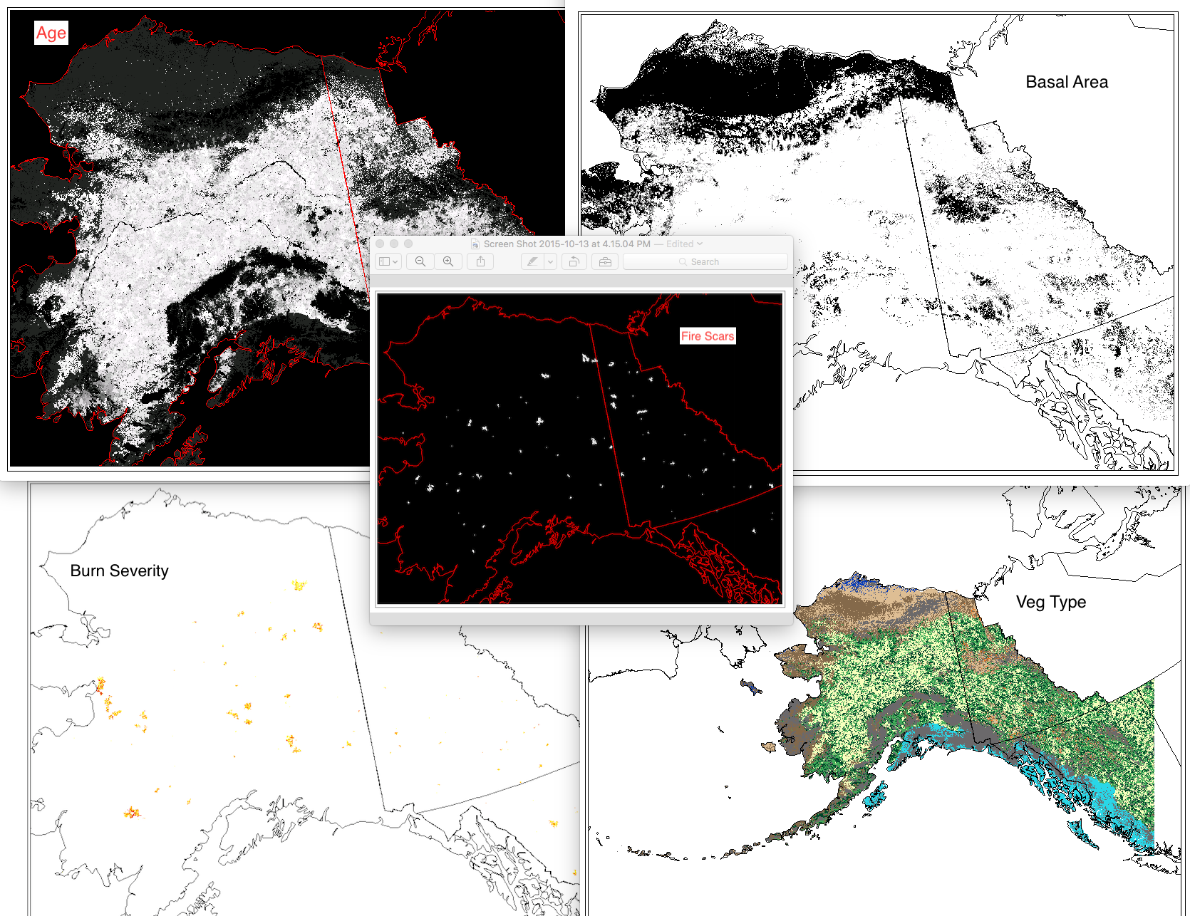
Variables include:
Veg: The dominant vegetation for this cell. Current values are:
0 = Not Modeled
1 = Black Spruce
2 = White Spruce
3 = Deciduous Forest
4 = Shrub Tundra
5 = Graminoid Tundra
6 = Wetland Tundra
7 = Barren / Lichen / Moss
8 = Temperate Rainforest
Age: This the age of the vegetation in each cell. An Age value of 0 means it transitioned in the previous year.
Basal Area: The accumulation of basal area of white spruce in tundra cell, and is influenced by seed dispersal, growth of biomass, climate data, and other factors.
units = m^2 / ha
Burn Severity: This is a categorical burn severity level of the previous burn in the current cell, influenced by fire size and slope. For example, a burn severity value in a file with year 1971 in the file name means that the severity level given to that file occurred in the fire that occurred in year 1970.
0=No Burn
1=Low
2=Moderate
3=High w Low Surface Severity
4=High w/ High Surface Severity
Fire Scar: These are the unique fire scars. Each cell has three values.
Band 1 - Year of burn
Band 2 - Unique ID for the simulated fire for that simulation year
Band 3 - Whether or not the cell was an ignition location for a fire. There will only be 1 ignition cell per fire per year.
0 = not ignition
1 = ignition point
For background on ALFRESCO, please refer to:
Is Alaska's Boreal Forest Now Crossing a Major Ecological Threshold?
Daniel H. Mann, T. Scott Rupp, Mark A. Olson, and Paul A. Duffy
Arctic, Antarctic, and Alpine Research 2012 44 (3), 319-331
Simple
- Date (Revision)
- 2017-10-24
- Edition
- 1.0.0
- Credit
- Alec Bennett
- Credit
- Michael Lindgren
- Credit
- Tom Kurkowski
- Credit
- Scott Rupp
- Credit
- This research is funded by the Arctic Landscape Conservation Cooperative, Western Alaska Landscape Conservation Cooperative, and Northwest Boreal Landscape Conservation Cooperative (LCCs) and the Alaska Climate Science Center.
- Status
- Completed
- Maintenance and update frequency
- As needed
- Theme
-
- wildfires
- Keywords
-
- vegetation
- Use constraints
- License
- Other constraints
- https://creativecommons.org/licenses/by/4.0/
- Spatial representation type
- Grid
- Denominator
- 30000
- Metadata language
- eng
- Character set
- UTF8
- Topic category
-
- Climatology, meteorology, atmosphere
- Begin date
- 1900-01-01
- End date
- 2100-12-31
))
- Reference system identifier
-
EPSG:3338
- Date
- Number of dimensions
- 2
- Dimension name
- Row
- Dimension size
- 3650
- Resolution
- 1000 meter
- Dimension name
- Column
- Dimension size
- 2100
- Resolution
- 1000 meter
- Cell geometry
- Area
- Distribution format
-
-
(
)
-
(
)
- OnLine resource
-
ALFRESCO Model outputs - linear coupled - Annual
(
WWW:LINK-1.0-http--link
)
Web accessible folder of model output
- Hierarchy level
- Dataset
- File identifier
- 53b35453-7b88-4ea7-8321-5447f8926c48 XML
- Metadata language
- English
- Character set
- UTF8
- Date stamp
- 2023-08-20T14:53:24
- Metadata standard name
- ISO 19115:2003/19139
- Metadata standard version
- 1.0
Overviews
Spatial extent
Provided by
