 SNAP GeoNetwork
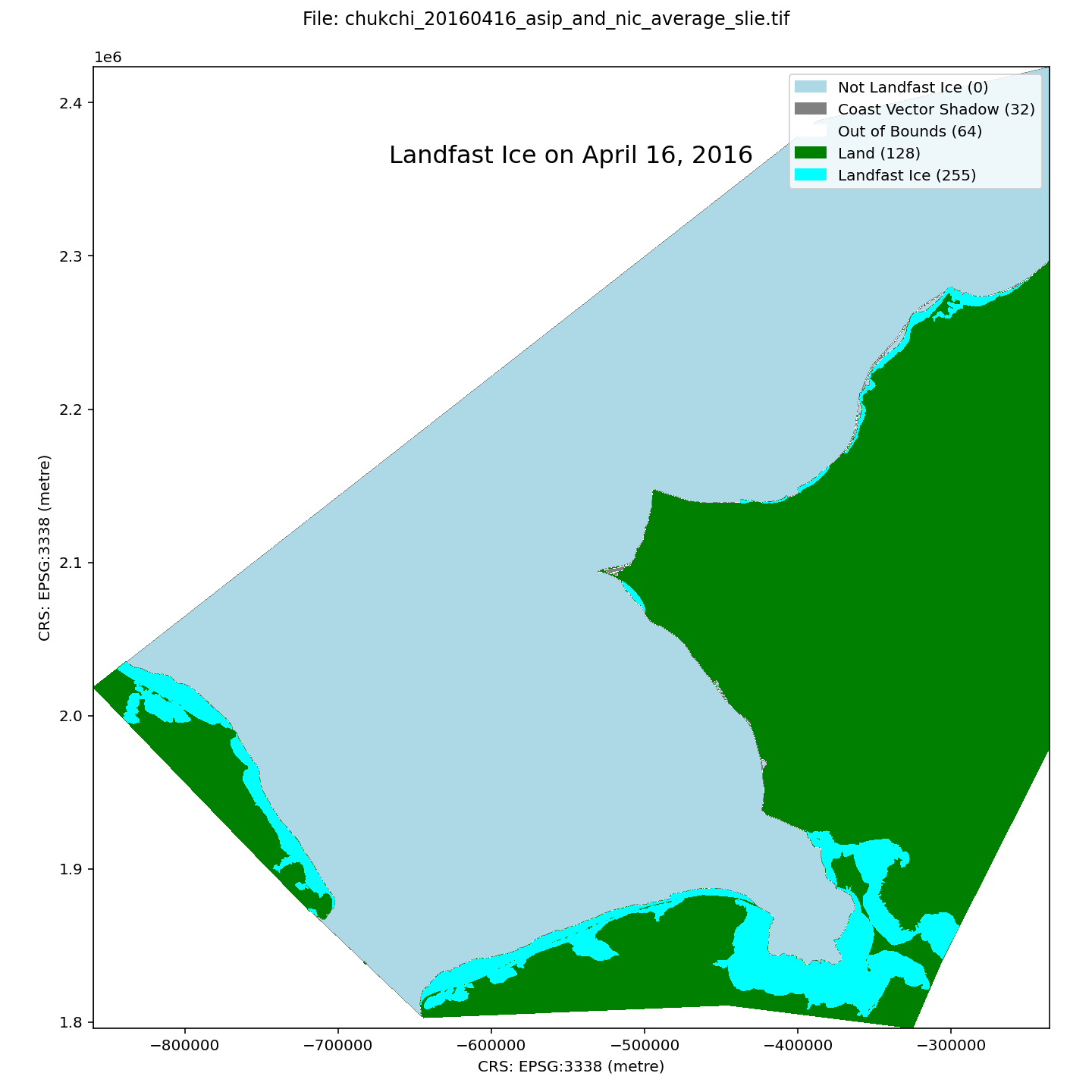
Chukchi Sea Daily Landfast Sea Ice Extent October 1996 – July 2023
A dataset of landfast ice extent along the Alaska coast of the Chukchi Sea and adjacent waters in Russia, spanning the winters of 1996-2023. Landfast ice extent is defined as the area between the coast and the seaward landfast ice edge (SLIE), meaning that small areas of open water than can form at the coast springtime will not be represented. Spatial resolution is 100 m. Compilation of the dataset is described in detail by Mahoney et al (2024). In brief, it is derived from three sources: From 1996-2008, the dataset is derived from analysis of sequential synthetic aperture radar (SAR) images from the RadarSAT and EnviSAT constellations, as described by Mahoney et al (2014); From 2008-2023, the data represent an average landfast extent identified in ice charts from the U.S. National Weather Service Alaska Sea Ice Program (ASIP) and the U.S. National Ice Center (NIC).
Within each GeoTIFF file there are 5 different pixel values representing different characteristics:
0 - Not Landfast Ice
32 - Coast Vector Shadow
64 - Out of Bounds
128 - Land
255 - Landfast ice
The file naming convention is as follows:
chukchi_$YYYYMMDD_$source_slie.tif
For example, the name
chukchi_20170302_asip_and_nic_average_slie.tif
indicates the file represents data for March 2, 2017 and that the data is derived from an average of the ASIP and NIC data sources.
These data were updated on August 21, 2025 to rectify the omission of some NIC chart data sources for the 2017-18 and 2018-19 seasons.
Simple
- Date (Publication)
- 2024-12-17
- Credit
- Andrew Einhorn
- Credit
- Andrew Mahoney
- Status
- Completed
- Maintenance and update frequency
- As needed
- Theme
-
- sea ice
- observed
- Use constraints
- License
- Other constraints
- https://creativecommons.org/licenses/by/4.0/
- Spatial representation type
- Grid
- Distance
- 100 m
- Metadata language
- eng
- Character set
- UTF8
- Topic category
-
- Climatology, meteorology, atmosphere
- Oceans
- Begin date
- 1996-10-01
- End date
- 2023-07-31
))
- Unique resource identifier
- EPSG:3338
- Number of dimensions
- 3
- Dimension name
- Time
- Dimension size
- 0
- Resolution
- 1 Day
- Dimension name
- Row
- Dimension name
- Column
- Cell geometry
- Area
- Distribution format
-
-
GeoTIFF
(
1.0
)
-
GeoTIFF
(
1.0
)
- OnLine resource
-
Chukchi Sea Landfast Sea Ice: Daily Seaward Landfast Ice Edge (SLIE) Extent October 1996-July 2023
(
WWW:LINK-1.0-http--link
)
URL to web-accessible folder containing downloads for this data set
- OnLine resource
- Mahoney AR, Bieniek P, Danielson S, Einhorn AH, Hedstrom KS, Jones JM, Klenz, T. (University of Alaska, Fairbanks, AK). 2024. Landfast ice climatology within the Arctic OCS. Anchorage (AK): U.S. Department of the Interior, Bureau of Ocean Energy Management. 121 p. Report No.: OCS Study BOEM 2024-034 ( WWW:LINK-1.0-http--link )
- Hierarchy level
- Dataset
- File identifier
- a6323019-0023-4e0d-98dc-a01b13bb7114 XML
- Metadata language
- English
- Character set
- UTF8
- Date stamp
- 2025-08-21T12:39:59
- Metadata standard name
- ISO 19115:2003/19139
- Metadata standard version
- 1.0
Overviews
Spatial extent
Provided by
