 SNAP GeoNetwork
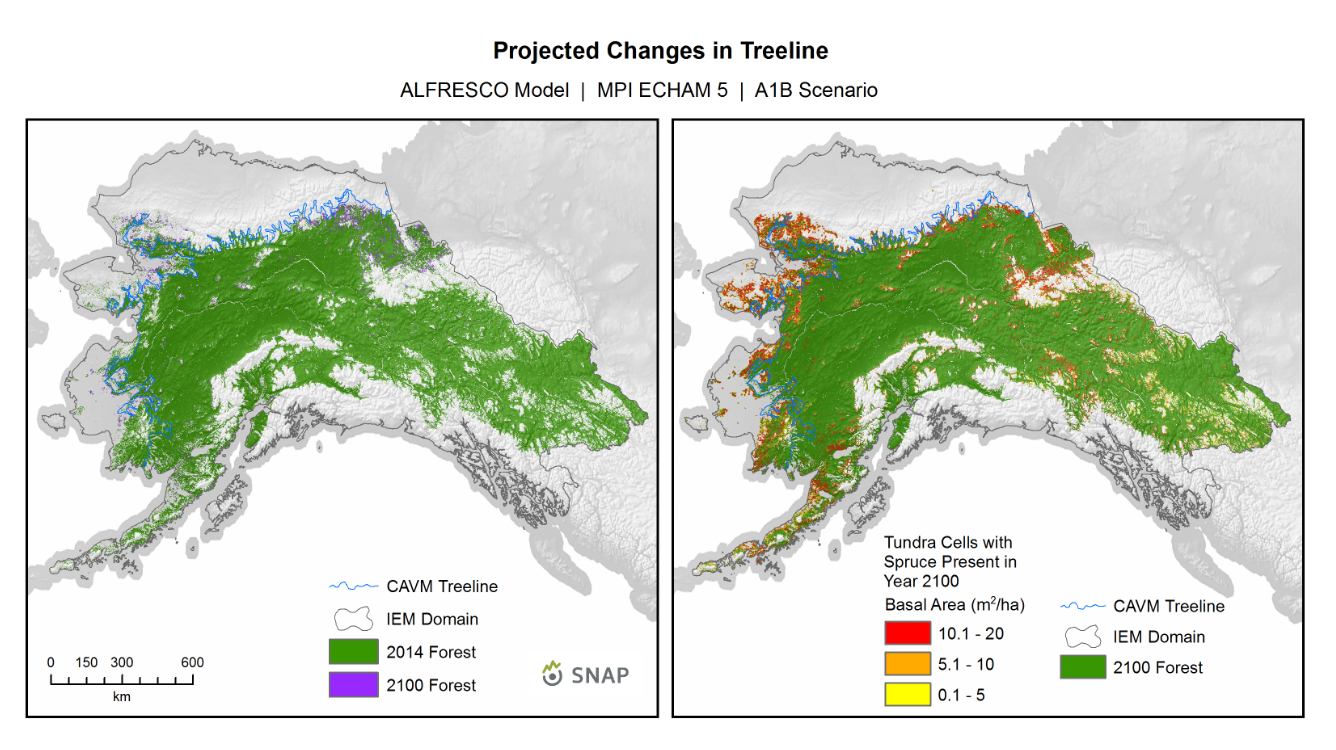
Treeline Maps - ALFRESCO Model Outputs - Linear Coupled
These are map products depicting modeled treeline dynamics. The left panel indicates modeled treeline dynamics from a single 2014 baseline year to the year 2100. The right panel indicates basal area accumulation on a 1km x 1km pixel basis during the year 2100, which gives an indication where possible further treeline advance may occur beyond 2100.
The source datasets used to create these maps can be found here:
ALFRESCO is a landscape scale fire and vegetation dynamics model. These specific outputs are from the Integrated Ecosystem Model (IEM) project, and are from the linear coupled version using AR4/CMIP3 and AR5/CMIP5 climate inputs (IEM Generation 1a).
These outputs include data from model rep 171(AR4/CMIP3) and rep 26(AR5/CMIP5), referred to as the “best rep” out of 200 replicates. The best rep was chosen through comparing ALFRESCO’s historical fire outputs to observed historical fire patterns. Single rep analysis is not recommended as a best practice, but can be used to visualize possible changes.
The IEM Generation 1 is driven by outputs from 4 climate models, and two emission scenarios:
AR4/CMIP3
SRES A1B
CCCMA-CGCMS-3.1
MPI-ECHAM5
AR5/CMIP5
RCP 8.5
MRI-CGCM3
NCAR-CCSM4
Simple
- Date (Creation)
- 2015-05-29
- Status
- Completed
- Maintenance and update frequency
- As needed
- Theme
-
- vegetation, modeled, treeline
- Use constraints
- License
- Spatial representation type
- Grid
- Metadata language
- eng
- Character set
- UTF8
- Topic category
-
- Climatology, meteorology, atmosphere
- Biota
))
- Unique resource identifier
- EPSG:3338
- Number of dimensions
- 3
- Dimension name
- Time
- Dimension name
- Row
- Dimension name
- Column
- Cell geometry
- Area
- Distribution format
-
-
(
)
-
(
)
- OnLine resource
-
Treeline Maps - ALFRESCO Model Outputs - Linear Coupled
(
WWW:LINK-1.0-http--link
)
URL to web-accessible folder containing downloads for this data set
- Hierarchy level
- Dataset
- File identifier
- e93f0c0f-4946-4922-9683-cf7d734058c6 XML
- Metadata language
- English
- Character set
- UTF8
- Date stamp
- 2025-02-11T07:26:23
- Metadata standard name
- ISO 19115:2003/19139
- Metadata standard version
- 1.0
Overviews
Spatial extent
Provided by
