 SNAP GeoNetwork
Chukchi Sea Landfast Sea Ice Extent Summarized by Month and 9-year Periods
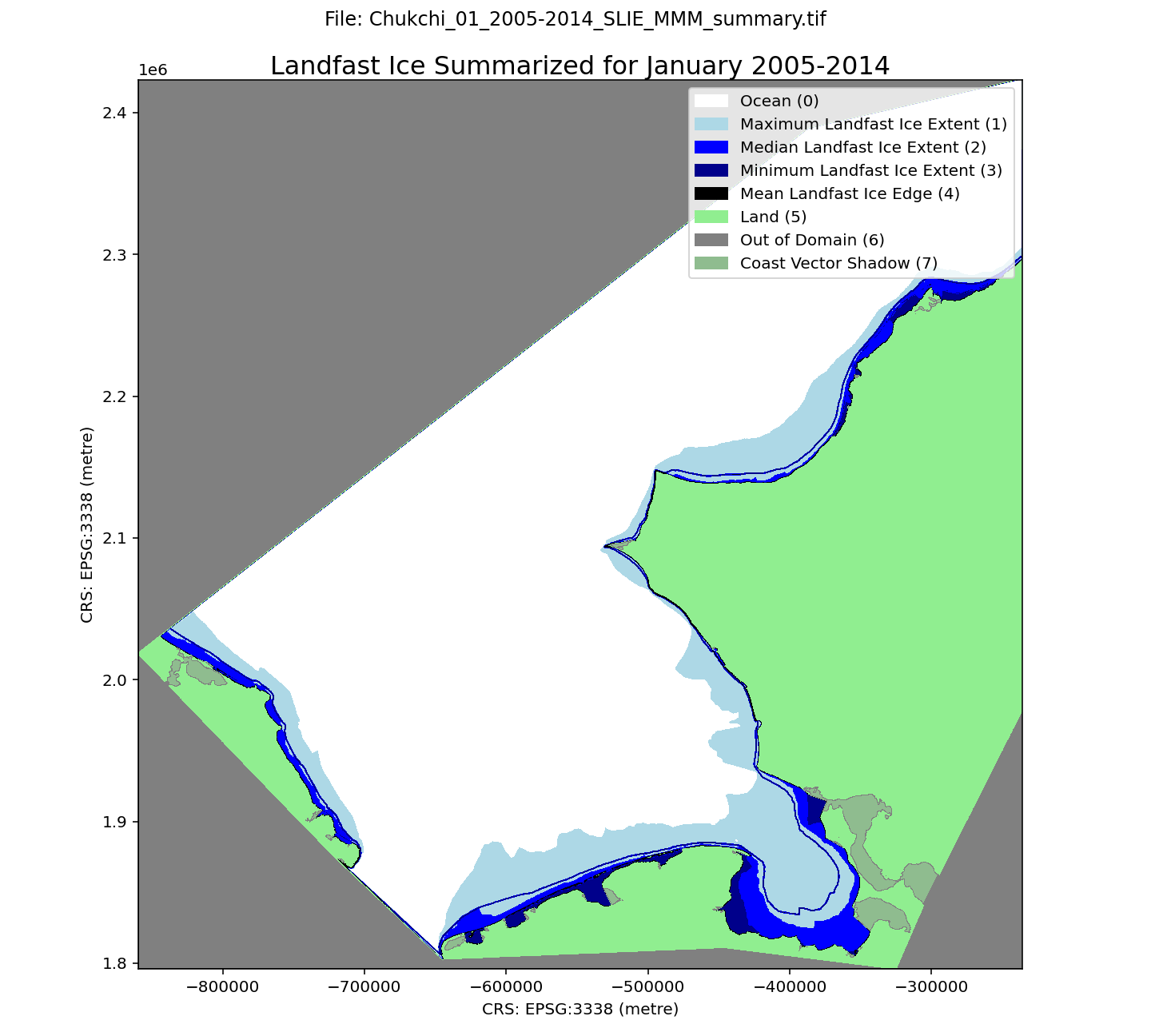
A landfast ice dataset along the Chukchi Sea continental shelf, spanning 1996-2023. Spatial resolution is 100 m. Each month of the ice season (October through July) is summarized over three 9-year periods (1996-2005, 2005-2014, 2014-2023) using the minimum, maximum, median, and mean distance of SLIE from the coastline. The minimum extent indicates the region that was always occupied by landfast ice during a particular calendar month. The median extent indicates where landfast occurred at least 50% of the time. The maximum extent represents regions that may only have been landfast ice on one occasion during the selected time period. The mean SLIE position for the each month and and time period is also included. The dataset is derived from three sources: seaward landfast ice images derived from synthetic aperture radar images from the RadarSAT and EnviSAT constellations (1996-2008), the Alaska Sea Ice Program (ASIP) ice charts (2008-2017, 2019-2022), and the G10013 SIGID-3 Arctic Ice Charts produced by the National Ice Center (NIC; 2017-2019, 2022-2023).
Within each GeoTIFF file there are 8 different pixel values representing different characteristics:
0 - Ocean
1 - Maximum Landfast Ice Extent
2 - Median Landfast Ice Extent
3 - Minimum Landfast Ice Extent
4 - Mean Landfast Ice Edge
5 - Land
6 - Out of Domain
7 - Coast Vector Shadow
The file naming convention is as follows:
Chukchi_$month_$era_SLIE_MMM_summary.tif
For example, the name
Chukchi_05_2005-2014_SLIE_MMM_summary.tif
indicates the file represents data for May 2005-2014.
These data were updated on August 21, 2025 to rectify the omission of some NIC chart data sources for the 2017-18 and 2018-19 seasons.
Simple
- Date (Publication)
- 2024-12-17
- Credit
- Andrew Einhorn
- Credit
- Andrew Mahoney
- Status
- Completed
- Maintenance and update frequency
- As needed
- Theme
-
- sea ice
- observed
- Use constraints
- License
- Other constraints
- https://creativecommons.org/licenses/by/4.0/
- Spatial representation type
- Grid
- Distance
- 100 m
- Metadata language
- eng
- Character set
- UTF8
- Topic category
-
- Climatology, meteorology, atmosphere
- Oceans
- Begin date
- 1996-10-01
- End date
- 2023-07-31
))
- Unique resource identifier
- EPSG:3338
- Number of dimensions
- 3
- Dimension name
- Time
- Dimension size
- 0
- Resolution
- 1 Day
- Dimension name
- Row
- Dimension name
- Column
- Cell geometry
- Area
- Distribution format
-
-
GeoTIFF
(
1.0
)
-
GeoTIFF
(
1.0
)
- OnLine resource
-
Chukchi Sea Seaward Landfast Ice Edge (SLIE) Extent Summarized by Month and 9-year Periods
(
WWW:LINK-1.0-http--link
)
URL to web-accessible folder containing downloads for this data set
- OnLine resource
- Mahoney AR, Bieniek P, Danielson S, Einhorn AH, Hedstrom KS, Jones JM, Klenz, T. (University of Alaska, Fairbanks, AK). 2024. Landfast ice climatology within the Arctic OCS. Anchorage (AK): U.S. Department of the Interior, Bureau of Ocean Energy Management. 121 p. Report No.: OCS Study BOEM 2024-034 ( WWW:LINK-1.0-http--link )
- Hierarchy level
- Dataset
- File identifier
- 0084b2b8-64ab-48bd-aacd-9fca5c0ea1f6 XML
- Metadata language
- English
- Character set
- UTF8
- Parent identifier
- Chukchi Sea Daily Landfast Sea Ice Extent October 1996 – July 2023 a6323019-0023-4e0d-98dc-a01b13bb7114
- Date stamp
- 2025-08-21T12:39:41
- Metadata standard name
- ISO 19115:2003/19139
- Metadata standard version
- 1.0
Overviews
Spatial extent
Provided by
