 SNAP GeoNetwork
Community Charts Temperature and Precipitation
Simple
- Date (Publication)
- 2022-03-08
- Unique resource identifier
- https://catalog.snap.uaf.edu/geonetwork/srv/eng/catalog.search#/metadata/b3b9581e-cccc-440f-bb2f-0fd6754d8d41
- Status
- Completed
- Maintenance and update frequency
- As needed
- Theme
-
- temperature
- precipitation
- historical
- projected
- modeled
- Place
-
- World
- Use constraints
- License
- Other constraints
- https://creativecommons.org/licenses/by/4.0/
- Spatial representation type
- Text, table
- Metadata language
- English
- Character set
- UTF8
- Topic category
-
- Boundaries
- Begin date
- 1961-01-15
- End date
- 2099-12-15
))
- Supplemental Information
-
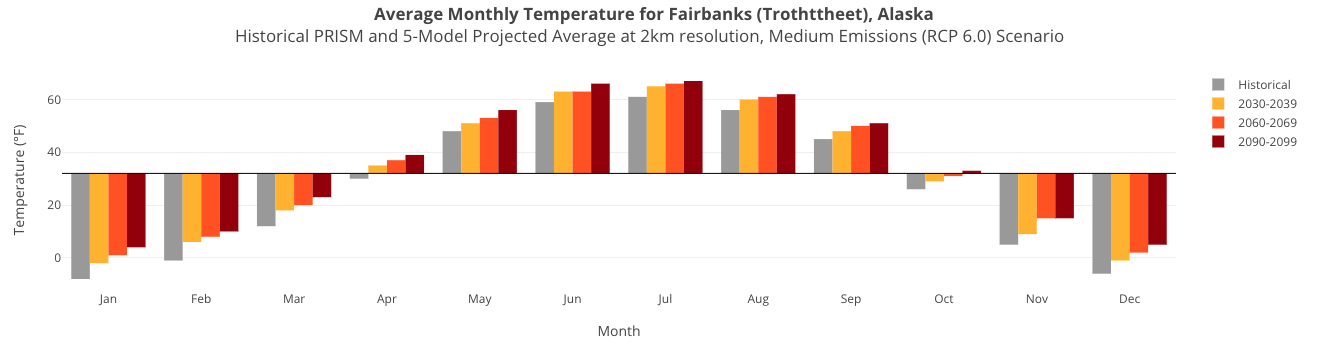
Temperature and precipitation values are provided for over 3,800 communities throughout Alaska and Western Canada for each of the following date ranges:
Historical (1961 - 1990)
2030 - 2039
2060 - 2069
2090 - 2099
Each mean temperature and precipitation value in the CSV is an average of single pixel data extractions from raster data over the corresponding date range. Min/max temperature values are taken from the years with the minimum and maximum values over the corresponding date range.
The following raster data sets were used:
Historical Monthly Temperature Products - 10 min CRU TS 3.22
Historical Monthly Precipitation Products - 10 min CRU TS 3.22
PRISM 1961-1990 Climatologies
Projected Monthly and Derived Temperature Products - 2km CMIP5/AR5
Projected Monthly and Derived Precipitation Products - 2km CMIP5/AR5
Projected Monthly Temperature Products - 10 min CMIP5/AR5
Projected Monthly Precipitation Products - 10 min CMIP5/AR5
The PRISM dataset is used as the historical baseline for each location except Northwest Territories locations. 2km projected data is used for these locations to match the resolution of the PRISM dataset.
Northwest Territories are not included in the PRISM data, so these locations use the CRU TS 3.22 dataset for their historical baseline. 10min projected data is used for these locations to match the resolution of the CRU TS 3.22 dataset.
Projected data are based on our 5-model average downscaled AR5 temperature and precipitation products.
Data fields include:
id
community
region
country
latitude
longitude
type
scenario
resolution
unit
daterange
janMin (all months, when available)
janMean (all months)
janMax (all months, when available)
- Reference system identifier
- WGS 1984
- OnLine resource
-
UAF SNAP Community Climate Charts
(
WWW:LINK-1.0-http--link
)
Webtool visualizing this dataset
- OnLine resource
-
SNAP Community Climate Charts Data
(
WWW:LINK-1.0-http--link
)
Link to this dataset
- Hierarchy level
- Dataset
- Source
-
- Projected Monthly and Derived Temperature Products - 2km CMIP5/AR5
- Projected Monthly and Derived Temperature Products - 2km CMIP5/AR5
- Projected Monthly and Derived Precipitation Products - 2km CMIP5/AR5
- PRISM 1961-1990 Climatologies
- Historical Monthly Temperature Products - 10 min CRU TS 3.22
- Historical Monthly Precipitation Products - 10 min CRU TS 3.22
- File identifier
- b3b9581e-cccc-440f-bb2f-0fd6754d8d41 XML
- Metadata language
- English
- Character set
- UTF8
- Date stamp
- 2024-12-16T10:55:18
- Metadata standard name
- ISO 19115:2003/19139
- Metadata standard version
- 1.0
Overviews
Spatial extent
Provided by
