 SNAP GeoNetwork
vegetation
Type of resources
Topics
Keywords
Contact for the resource
Provided by
Years
Formats
Representation types
Update frequencies
status
Scale
Resolution
-

This 1km land cover dataset represent highly modified output originating from the Alaska portion of the North American Land Change Monitoring System (NALCMS) 2005 dataset as well as the National Land Cover Dataset 2001. This model input dataset was developed solely for use in the ALFRESCO, TEM, GIPL and the combined Integrated Ecosystem Model landscape scale modeling studies and is not representative of any ground based observations. Use of this dataset in studies needing generalized land cover information are advised to utilize newer versions of original input datasets (2005 NALCMS 2.0, NLCD), as methods of classification have improved, including the correction of NALCMS classification errors. Original landcover data, including legends: NALCMS http://www.cec.org/north-american-land-change-monitoring-system/ NLCD 2001 https://www.mrlc.gov/data?f%5B0%5D=region%3Aalaska Final Legend: value | class name 0 | Not Modeled 1 | Black Spruce Forest 2 | White Spruce Forest 3 | Deciduous Forest 4 | Shrub Tundra 5 | Graminoid Tundra 6 | Wetland Tundra 7 | Barren lichen-moss 8 | Heath 9 | Maritime Upland Forest 10 | Maritime Forested Wetland 11 | Maritime Fen 12 | Maritime Alder Shrubland** Methods of production: Due to specific models' land cover input requirements, including the fact that each model is primarily focused on different descriptive aspects of land cover (i.e. ALFRESCO considers land cover in respect to how it burns, TEM considers land cover in respect to how it cycles carbon through the system, and GIPL considers land cover with respect to its influence on the insulative qualities of the soil).
-
These data contain historical and future projections of percent land cover from 1950 to 2100, as simulated by the Alaska Thermokarst Model for the boreal region. The data are 1km spatial resolution. The climate data used to drive the model simulations are from the Climate Research Unit, Time Series 4.0 (CRU_TS40) for the historical period (1950 to 2015), and from RCP 8.5 and global circulation models NCAR-CCSM4 and MRI-CGCM3 for the projected period (2016 to 2100). Datasets from the years 1950, 2000, 2050, and 2100 are provided. Annual maps are available upon request. Please note that this data is used to fill in a gap in available data for the Integrated Ecosystem Model (IEM) and does not constitute a complete or precise measurement of this variable in all locations. If used for publication, these data should be cited as the following: Genet H., Lara M., McGuire A.D., Jorgenson T.M., Euskirchen E.S., Clein J., Carman T., Rutter R., Rupp S., Breen A., Kurkowski T., Bennett A., Torgenson B., Romanovski V., Marchenko S. 2018. Land cover dynamic in the Tanana Flats from 1950 to 2100 driven by thermokarst activity.
-
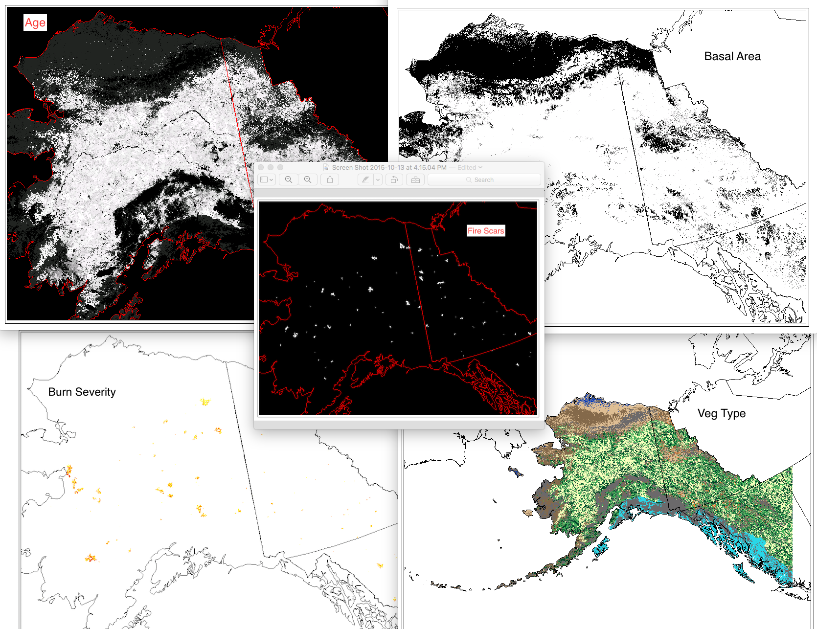
This set of files includes annual model outputs from ALFRESCO, a landscape scale fire and vegetation dynamics model. These specific outputs are from the Integrated Ecosystem Model (IEM) project, and are from the linear coupled version using AR4/CMIP3 climate inputs (IEM Generation 1-AR4) and AR5/CMIP5 climate inputs (IEM Generation 1-AR5). These outputs include data from model rep 171(IEM Generation 1-AR4) and rep 26 (IEM Generation 1-AR5), referred to as the “best rep” out of 200 replicates. The best rep was chosen through comparing ALFRESCO’s historical fire outputs to observed historical fire patterns. Single rep analysis is not recommended as a best practice, but can be used to visualize possible changes. Climate models and emission scenarios: IEM Generation 1-AR4/CMIP3 CCCMA-CGCMS-3.1 MPI-ECHAM5 under the SRES A1B scenario IEM Generation 1-AR5/CMIP5 MRI-CGCM3 NCAR-CCSM4 under RCP 8.5 scenario Variables include: Veg: The dominant vegetation for this cell. Current values are: 0 = Not Modeled 1 = Black Spruce 2 = White Spruce 3 = Deciduous Forest 4 = Shrub Tundra 5 = Graminoid Tundra 6 = Wetland Tundra 7 = Barren / Lichen / Moss 8 = Temperate Rainforest Age: This the age of the vegetation in each cell. An Age value of 0 means it transitioned in the previous year. Basal Area: The accumulation of basal area of white spruce in tundra cell, and is influenced by seed dispersal, growth of biomass, climate data, and other factors. units = m^2 / ha Burn Severity: This is a categorical burn severity level of the previous burn in the current cell, influenced by fire size and slope. For example, a burn severity value in a file with year 1971 in the file name means that the severity level given to that file occurred in the fire that occurred in year 1970. 0=No Burn 1=Low 2=Moderate 3=High w Low Surface Severity 4=High w/ High Surface Severity Fire Scar: These are the unique fire scars. Each cell has three values. Band 1 - Year of burn Band 2 - Unique ID for the simulated fire for that simulation year Band 3 - Whether or not the cell was an ignition location for a fire. There will only be 1 ignition cell per fire per year. 0 = not ignition 1 = ignition point For background on ALFRESCO, please refer to: Is Alaska's Boreal Forest Now Crossing a Major Ecological Threshold? Daniel H. Mann, T. Scott Rupp, Mark A. Olson, and Paul A. Duffy Arctic, Antarctic, and Alpine Research 2012 44 (3), 319-331 http://www.bioone.org/doi/abs/10.1657/1938-4246-44.3.319
-
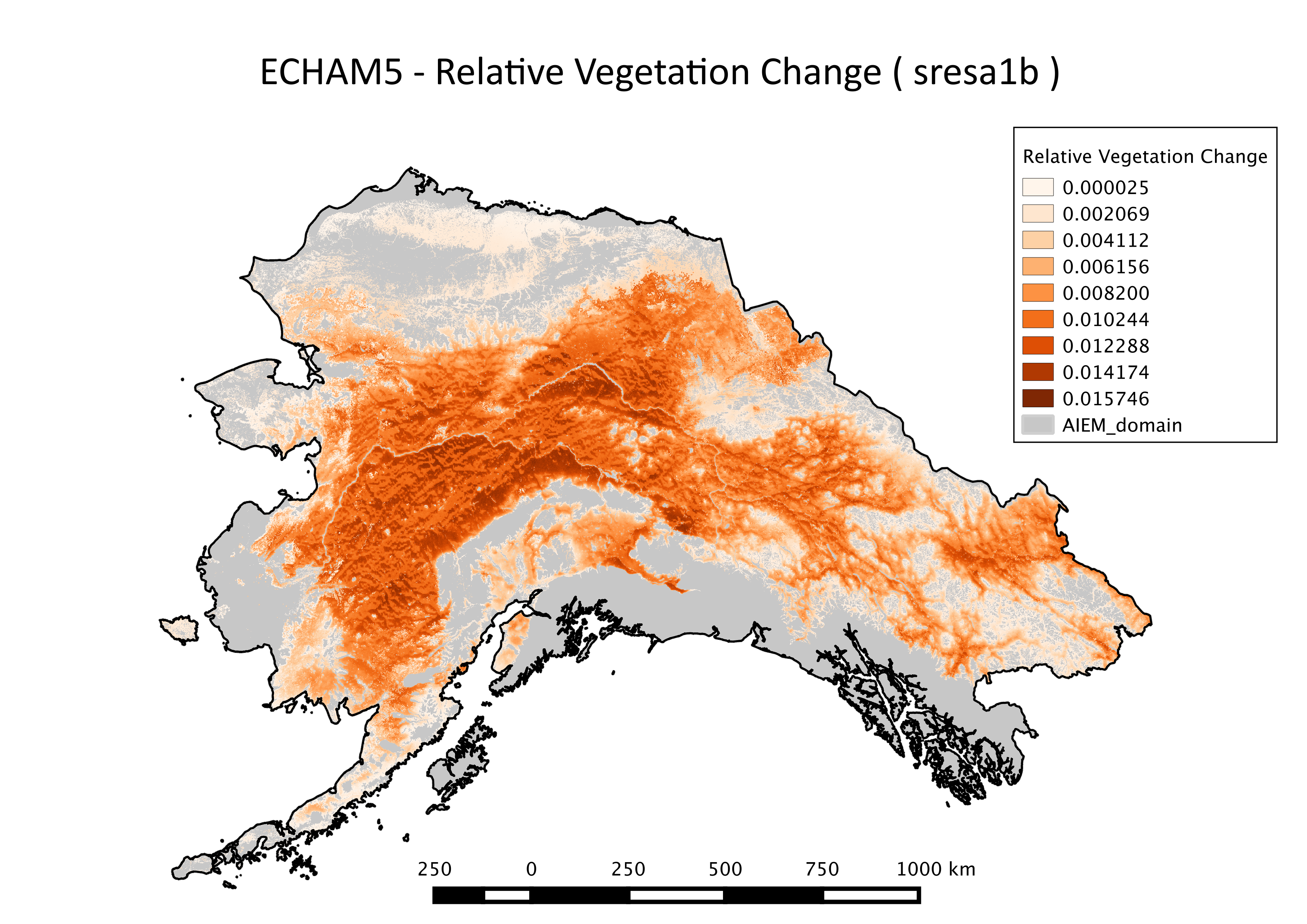
This dataset consists of spatial representations of relative vegetation change produced through summarization of ALFRESCO model outputs. These specific outputs are from the Integrated Ecosystem Model (IEM) project, and are from the linear coupled version using AR5/CMIP5 climate inputs (IEM Generation 2).
-
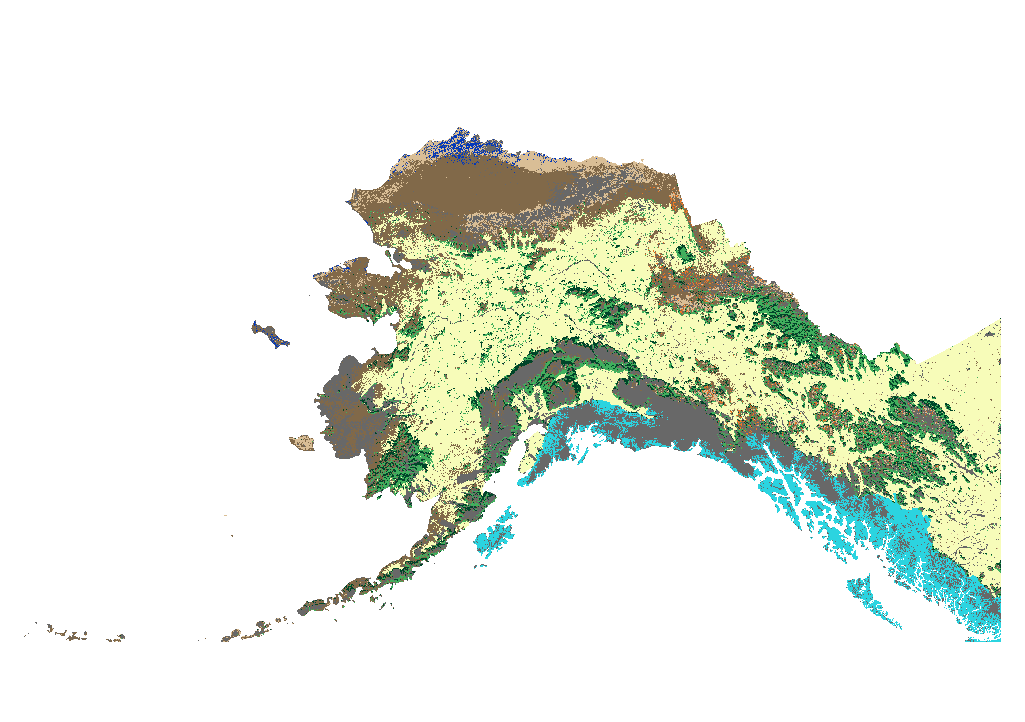
This dataset consists of spatial representations of vegetation types produced through summarization of ALFRESCO model outputs. These specific outputs are from the Integrated Ecosystem Model (IEM) project, AR5/CMIP5 climate inputs (IEM Generation 2). ALFRESCO outputs were summarized over three future eras (2010-2039, 2040-269, 2070-2099) and a historical era (1950-2008). Both the proportions of all possible vegetation types and the modal vegetation type (most common type over a given era) are available as sub-datasets. Each are summarized over two future emissions scenarios for five CMIP5 models.
-
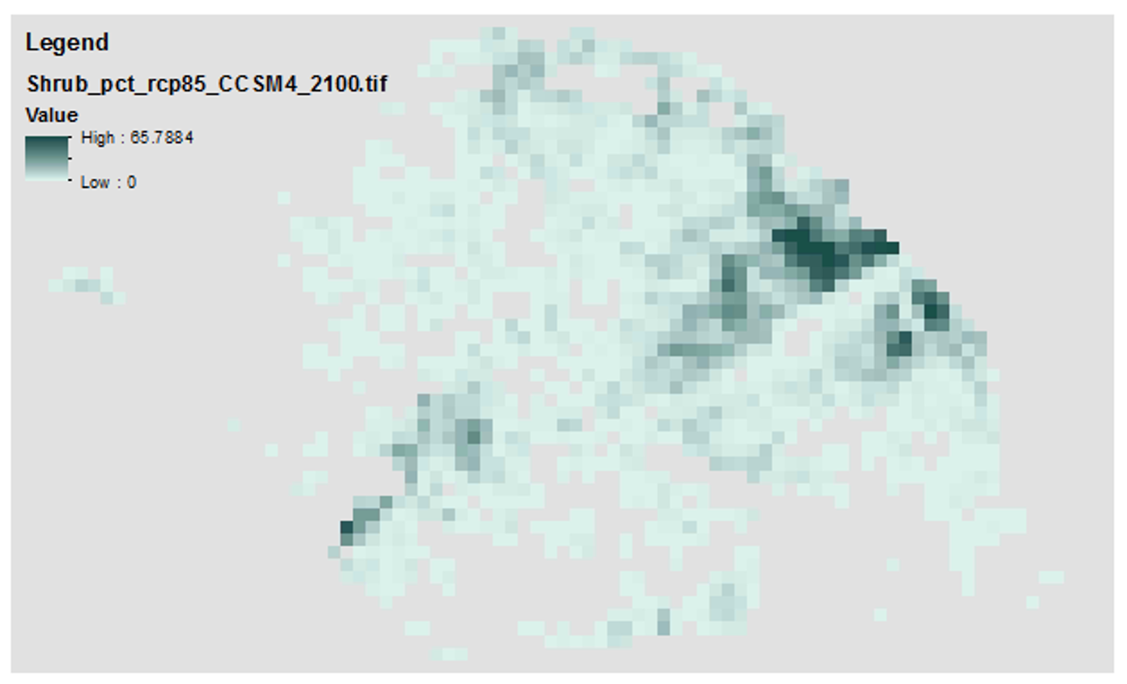
These GeoTIFFs include annual spatial representations of the following variables produced through summarization of ALFRESCO model outputs across 200 replicates: Flammability: likelihood of a pixel to burn across 200 replicates Modal vegetation type: statistical mode of vegetation type across 200 replicates Percent vegetation type: percent of each possible vegetation type across 200 replicates These outputs were derived from AR5/CMIP5 climate inputs, historical fire inputs from the Alaska Interagency Coordination Center (AICC), and several fire management options (FMO) inputs.